• SCLD
  • Services
  • Current Projects
  • Portfolio
  • Blog
  • Events
  • Connect
  • Awards
  • Opportunities
Menu

Stephen Caffyn Landscape Design

Landscape Architecture, Landscape Design & Environmental Planning
  • SCLD
  • Services
  • Current Projects
  • Portfolio
  • Blog
  • Events
  • Connect
  • Awards
  • Opportunities

Stephen Caffyn Landscape Design is currently working on several projects in Singapore and the Region.

Key current projects include Teachers Estate Park'; Khatib Bongsu Nature Park; Sisters Island Marine Park; Phase 1B of the Round Island Route - Coastal Adventure; Multiple small Parks; Adaptive reuse of a former industrial / MRT site; and several interesting HDB’s (high rise residential public housing projects).
Here is a taster of some of the projects - more information later on these. 

Round Island Route - Coastal Adventure

Round Island Route (RIR), Singapore

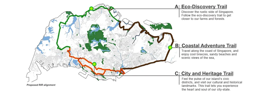
The Round Island Route is a proposed 150Km long recreational walking and cycling route that circumnavigates Singapore. The RIR will connect existing rural, industrial, civic, residential, recreational, urban, natural, cultural, and historic locations with exciting new features, facilities and elements.

Coastal Adventure - RIR Corridor B

The RIR is divided into 3 Corridors and the eastern portion of the route, the "Coastal Adventure" (Corridor B), which is approximately 60km in length, and will be the first corridor of the RIR to be developed.
Continuing from our initial Masterplanning work on the RIR, Stephen Caffyn Landscape Design (SCLD) is pleased to have been awarded the Landscape Architectural consultancy for this this major recreation and infrastructure project in Singapore.

The population catchment of the Coastal Adventure Corridor encompasses the largest population concentration of the three corridors with large clusters along East Coast Parkway, Pasir Ris, Punggol and Sengkang. The route will connect and integrate with existing waterside parks, the park connector network, places of interest, and cultural and natural heritage sites.

Our design proposals incorporate measures to conserve and improve habitats along the route and increase biodiversity as well as recreational facilities and features.


RIR Coastal Adventure Consultant Team:

Landscape Architects: Stephen Caffyn Landscape Design (SCLD)
Architects: AWP Architects
Civil & Structural Engineers: Arup Singapore
Mechanical & Electrical Engineers: Arup Singapore
Quantity Surveyors: WTPartnership

More on this project soon.

All plans, visualizations, graphics, videos, and photos are produced by SCLD used are with the permission of the National Parks Board (NParks).

All Rights Reserved

The Round Island Route (RIR) - Corridors

Overall masterplan for the 150km Round Island Route indicating the Corridor theming.

Round Island Route RIR Rower's Bay 1 SCLD

Aerial view of Rower's Bay node of the Round Island Route, Coastal Adventure, Singapore.
 

Round Island Route Rower's Bay 2 SCLD

View of shelter at Rower's Bay node of the Coastal Adventure section (Corridor B) of the Round Island Route (RIR). 

Round Island Route - Rower's Bay 3 SCLD

View of Rower's Bay node of the Coastal Adventure section (Corridor B) of the Round Island Route (RIR) from Lower Seletar Reservoir, Singapore. 

Round Island Route Rower's Bay 4 SCLD

View of Restroom facilities at Rower's Bay node of the Round Island Route.

Round Island Route Rowers Bay 5 SCLD

View of Rower's Bay node showing proposed wetland and boardwalk area.

Round Island Route Rowers Bay 6 SCLD

View of Rower's Bay wetland and boardwalk area from the reservoir.

Round Island Route Rowers Bay 7 SCLD

Visualization of swale behind the shelter at Rower's Bay node.

Round Island Route Changi Bay 1 SCLD

High level aerial view visualization of Changi Bay area of the Round Island Route (RIR) - Coastal Adventure    

Round Island Route Changi Bay 2 SCLD

Visualization of RIR track leading to the Changi Bay area - Round Island Route - Coastal Adventure   

Round Island Route Changi Bay 3 SCLD

Visualization of a RIR Shelter at the headland seawall of Changi Bay area - Round Island Route - Coastal Adventure   

Round Island Route Changi Bay 4 SCLD

Visualization of a RIR Shelter at the seawall of Changi Bay area - Round Island Route - Stephen Caffyn Landscape Design

Round Island Route Changi Bay 5 SCLD

View of Landscape Bridge proposed over new canal 

Round Island Route Changi Bay 6 SCLD

Changi Bay Beach area with new restrooms and facilities 

Round Island Route Changi Bay 7 SCLD

Green roofed restrooms at Changi Bay beach area

Early Masterplanning and Theming of the Round Island Route

SCLD's early masterplanning work for the Round Island Route (RIR) and Corridor A.

Bishan to City - Feasibility Study

Bishan to City Feasibility Study, Singapore

The aim of the planning study is to further progress of the National Cycling Master Plan by providing seamless connectivity between Bishan and the City along the Kallang River. This URA commissioned study will determine the technical feasibility of a series of pedestrian and cycling friendly crossings along the Kallang Park Connector with the aim of creating a seamless route.

The planning study also intends to enhance the entire route, and considers criteria such as aesthetics, functionality, buildability, and cost.

Major road obstacles such as the PIE and Sims Avenue mean that the current PCN route is fragmented and in places difficult or dangerous for PCN users. The study looks at options and solutions to resolve these issues and connect the entire route whilst also incorporating themes and references to the historical, cultural, and biological diversity along the Kallang River.

Our Bishan to City Feasibility Study formed part of the URA exhibition “A River Runs Through It” featured on our blog in March 2017.

Awards:

Gold Award - Singapore Landscape Architecture Awards 2017


Bishan to City Feasibility Study - Consultant Team:

Landscape Architects & Cycling Consultant: Stephen Caffyn Landscape Design (SCLD)
Architects: AWP Architects
Bridge Consultants: Dissing+Weitling Architecture
Civil & Structural Engineers: Meinhardt Singapore
Mechanical & Electrical Engineers: Meinhardt Singapore
Quantity Surveyors: WTPartnership

More on this project soon.

All plans, visualizations, graphics, videos, and photos are produced by SCLD and are used with the permission of the Urban Redevelopment Authority (URA).

All Rights Reserved

Bishan to City CTE Underpass 1 SCLD

Visualization of improved underpass at the CTE, Bishan to City, Singapore.

Bishan to City Sims Ave Underpass 1 SCLD

Aerial view of Sims Avenue underpass beside Kallang MRT Station. On the Bishan to City (Kallang PCN), Singapore

Bishan to City Sims Ave 2 SCLD

Visualization of southern entrance of Sims Avenue underpass by Stephen Caffyn Landscape Design for the Bishan to City project. 

Bishan to City Sims Ave 3 SCLD

Visualization of track leading to the underpass at Sims Avenue for the Bishan to City Feasibility Study project.

Bishan to City Themes 1 SCLD

Illustration of 'The Living River' themes to be implemented for the Bishan to City project.

Bishan to City - Location Plan 1 SCLD

Crossing location plan for Bishan to City Feasibility Study

TTDI Ayana - Residential Development

TTDI Ayana, Kwasa Damansara, KL, Malaysia

TTDI Ayana is a  5.1 hectare, mixed residential development, located in State of Selangor Darul Ehsan, Malaysia. It comprises of various unit types including condominium and townhouses, with shared facilities such as the club house, swimming pool, exercise corners, jungle stream, jungle play, three generation exercise and play, multipurpose courts, and allotment gardens. Located adjacent to the proposed city park, TTDI Ayana is designed with sustainability in mind and the grounds reflect this with an idealised natural environment utilising tropical native plants, featuring a jungle stream, and a myriad of theme gardens for residents to enjoy.

The development is due to be launched in the later half of 2018.


TTDI Ayana  - Consultant Team:

Landscape Architects: Stephen Caffyn Landscape Design (SCLD)
Architects: CL&O Architects
Local Landscape Architects: PTA Design
 

More on this project soon.

All plans, visualizations, graphics, videos, and photos are produced by SCLD and are used with the permission of the Naza TTDI.

All Rights Reserved

TTDI Ayana 1 SCLD
TTDI Ayana 1 SCLD

Older masterplan for this residential project featuring townhouses, high-rise condominium, and clubhouse facilities surrounding a large central recreation space. NB This plan dates from 2016 and is now superseded.

TTDI Ayana 2 SCLD
TTDI Ayana 2 SCLD

Visualization of the pool area - View across pool towards Clubhouse

prev / next
Back to Current Projects
RIR Changi Bay1 Stephen Caffyn Landscape Design.jpg
16
Round Island Route - Coastal Adventure
CTE-01+ppl-logo.jpg
6
Bishan to City - Feasibility Study
D5- Bar area is different now.jpg
2
TTDI Ayana - Residential Development

Powered by Squarespace